The INCLI-pro application allows the user to save the data resulting from inclinometric measurements and auxiliary measurements (location of the inclinometer, measurement of inclinometric column spiral angle as well as actual inclinometric measurements) and next, to process the said data as well as to interpret it and perform relevant analyses. All the data is represented in a fairly intuitive style; a graphic interface has been employed offering complete layout configuration as well as the data presentation units.
The INCLI-pro application is an excellent and universal tool serving the purposes of both large corporations handling a variety of inclinometers and smaller companies where a number of columns’ measurements are analysed.
The INCLI-pro application allows the user to classify all loaded inclinometers into projects while each of the inclinometers may be assigned to a number of projects at the same time. An actual project features a common and uniform co-ordinate system determining the location of the points. A project is described by means of the data specific to its name, location, owner and comments loaded by the application user and without a doubt, the inclinometers assigned to the project. Classification of inclinometers into projects allows the user to simplify the data organisation and definitely to easily navigate by them.
Fundamental benefits resulting from the INCLI-pro application and allowing the user to recognise it among other products available on the market are as follows:
- Storage of measurement results in the databases kept in a server or in local databases.
- Availability of a server-based release co-operating with MS SQL Server and Oracle Database.
- As distance between measurements can be different, INCLI-pro works with In Place inclinometers.
- Various unit systems.
Very high level of data safety.
- Arrangement of inclinometers in the project structure.
- The option to establish different rights of access to the databases. Users Manager.
- Very quick simultaneous access to all the measurements.
- Advanced analytical module.
- The option to select not only the inclinometer foot as a reference point (as in other applications) but also the inclinometer top or any other point. This allows the user to continue with the measurements in the case where the bottom part of the column gets either cut or damaged.
- The option to make the analysis of deformations and their dynamics in each and every selected direction, not only for A and B planes.
- Animations – automatic changing the direction of projection plane.
- Analysis of deformation dynamics and of deformation rate versus time.
- Presentation of results as a function of either column length or elevation.
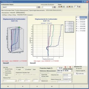
- An advanced graphical module allowing a 3D presentation of inclinometric column shape and 3D column deformation.
- A complete chart editing package with the option to customise them to serve the user’s purpose.
- Comprehensive options to adapt the printouts to serve the user’s purpose.
- Links to the maps: option to present the inclinometers automatically against a map background (DWG, DXF, BMP, JPG, TIF, PCX + many other formats).
- The option to edit and printout vectorial maps (DWG, DXF).