The TECHBASE Environmental Monitoring Package was designed to monitor environmental sites, and generate reports for regulatory agencies. You can set up alerts that automatically let you know when chemical limits have been exceeded, and generate reports and maps describing your project in detail. The TECHBASE Environmental Monitoring Package includes our Technicn program, allowing you to automate tasks you may perform only periodically - simplifying the reporting and monitoring process.
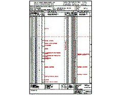
Logs
- Plot Geology as patterns and/or colors with descriptions.
- Plot Analyses as values, histograms or traces.
- Templates provided, create your own logs or hire us to help you.
Model Data
- Composite (average) down hole data into intervals, rock types, benches or user defined variables
- Model your data using the Inverse Distance algorithm to interpolate between data points
- Populate 3D block tables or 2D cell tables using TECHBASE modeling
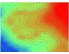
- Calculate volumes, plot surfaces or contour surface and subsurface data
- Locate data within boundaries such as land ownership limits
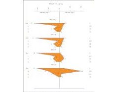
Statistics & Graphs
- Summary statistics
- Correlation and Regression analysis
- Cumulative frequency plots
- Duplicate Data Analysis
- X-Y (Scatter) Plots
- Histograms
- Time Series Diagrams
- Ternary Diagrams - Triangular Plots
Data Storage and Reporting
- Store environmental data in a TECHBASE Database
- Define your own data parameters, limits, type, perform inter-record calculations
- Special fields designed for environmental data
- Full filtering, searching, validating capabilities
- Connect to ODBC compliant databases
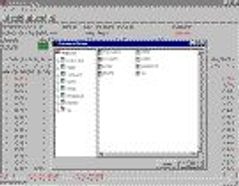
- Load data from outside sources or enter directly into TECHBASE
- Excedence Reports
- Create reports of data in full, subsets, averages, totals and more
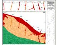
Cross Sections
- Plot Surveyed or unsurveyed holes
- Plot Geology as patterns or colors
- Plot analyses as values, histograms or traces
- Cross, top and side views
- Fence Diagrams
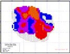
Mapping
- Basemaps
- Topographic Maps
- Maps of monitoring wells
- Plot multiple values adjacent to wells, sample locations
- Geologic Maps
- Drill Hole Location Maps
- Land Maps
- Maps of Land Features
Productivity Module
Create tasks using the TECHBASE Technicn program to automate:
- Excedence Reports
- Well monitoring results filtered by date, location, time etc.
- Multiple cross-section, log, map creation
- Create tasks for any TECHBASE module
- Combine tasks into organized steps
- Create tasks for non technical personnel to run periodically
- Create input screens for technician use
- Limits = your imagination!
Additional Capabilities
- Contour modeled or raw (XYZ) data
- Interactively edit graphics - add title blocks, move points etc.
- Convert data from one coordinate system to another 'on the fly' while creating TECHBASE graphics
- Edit all graphics on screen
- Print graphics or save to a variety of transportable formats
- 6 months of unlimited technical support included in purchase
- Self-paced tutorial included in package
Expansion
Need more capabilities? No need to buy another software package. Purchase additional TECHBASE modules to:
- View your data with our 3D viewer - spin, rotate, zoom and pan through your project area producing stunning graphics
- Calculate Slope Stability
- Calculate volumes and tonnages
- Model groundwater flow
- And much, much more