LOGitEASY's web-based soil logging and boring log software (LOGitEASY eForm) is usable both in the field and in the office for transferring field notes. Once the data is entered into the software, logs can be produced in a variety of templates, incl...
Combine geometries and analyses in a single project GeoStudio enables you to combine analyses using different products into a single modeling project, using the results from one as the starting point for another. Multiple geometries, including...
A managed code .NET GIS SDK for developing professional web GIS applications for hosting on Windows, Linux, and macOS servers (including Docker). The SDK is designed and compiled natively for ASP.NET Core and Web Forms, with support for MVC and Razo...
EDMS is used to improve and standardize environmental data collection, management, and reporting in an efficient and cost-effective manner. This is accomplished by implementing a documented, auditable process for the collection, storage, and reportin...
A professional grade GIS software development kit (SDK) used by customers in a wide range of industries to develop custom GIS applications or add geospatial functionality to existing products. SDK editions are compiled natively for the Delphi/C++Bui...
Making segmental retaining wall design simple, fast and more cost-effective Now there’s a better way to design segmental retaining walls: introducing TensarSoil design software from Tensar International. Fully interactive, this new program allows yo...
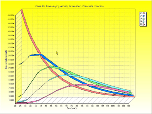
The POLLUTEv7 program provides fast, accurate, and comprehensive contaminant migration analysis capabilities. This program implements a one and a half dimensional solution to the advection-dispersion equation. Unlike finite element and finite differe...
Terrain Tools® is a software toolkit for 3D mapping, terrain modelling and land development. Terrain Tools® includes a variety of 3D mapping functions, as well as engineering design functions.Includes functions for: surveying, coordinate geometry, im...
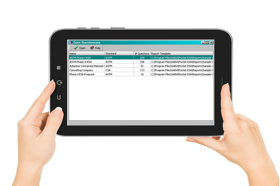
E-ASR has been designed to minimize the amount of time required to generate standard Environmental Site Assessment reports and to maximize the flexibility of the final report. The program is used to collect answers to pre-designed questions. The dat...
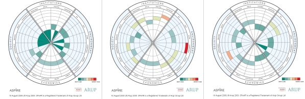
ASPIRE is an essential tool for those funding, commissioning and implementing infrastructure projects in developing countries. This easy to use software allows organisations to evaluate the impact of their work and maximise their contribution to po...
Hydro GeoAnalyst (HGA) is our comprehensive and easy-to-use environmental data management system. HGA integrates customizable database structures used around the world with state-of-the-art tools for data interpretation, statistical analysis, Geograp...
GS+ is a comprehensive geostatistics program that is fast, efficient, and easy to use. GS+ provides all geostatistics components, from variogram analysis through kriging and mapping, in a single integrated program widely praised for its flexibility a...
The POLLUTEv7 program provides fast, accurate, and comprehensive contaminant migration analysis capabilities. This program implements a one and a half dimensional solution to the advection-dispersion equation. Unlike finite element and finite differe...
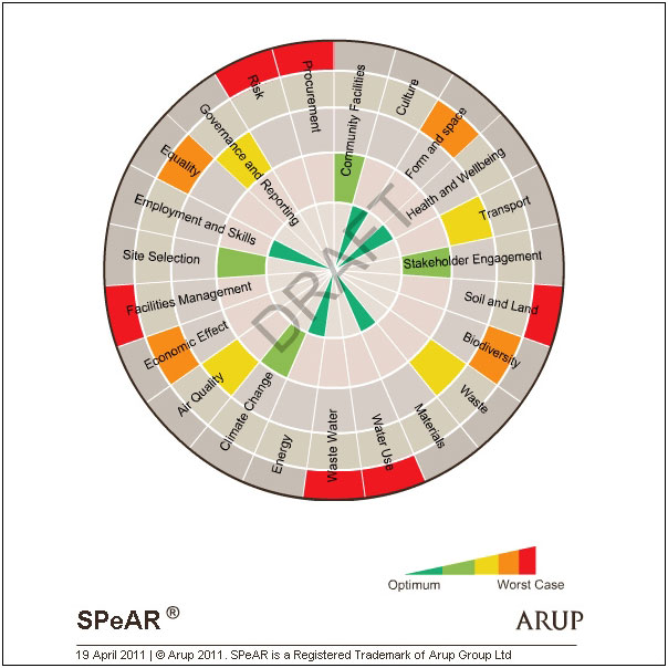
The perfect choice for a comprehensive and holistic assessment of sustainabilitySPeAR® (Sustainable Project Appraisal Routine) is Arup's in-house sustainability appraisal tool and provides a holistic decision making framework to support project devel...