SeismoMatch is an application capable of adjusting earthquake accelerograms to match a specific target response spectrum, using the wavelets algorithm proposed by Abrahamson [1992] and Hancock et al. [2006]. Some of its features are: Simultaneo...
PLog – The most comprehensive mobile data collection system for borehole and test pit data. AGS compliant. PLog is a system that facilitates the generation of geotechnical borehole logs by managing the dataflow process from field data collecti...
Specialist environmental database system used by consultants and site managers ESdat allows for efficient importing from a range of systems or data sources into a central environmental database; provides data comparison and analysis, comprehensive r...
PLog Enterprise software allows you to harness the power of your gINT project database while taking it to the next level - a KnowledgeBase™. The PLog Enterprise KnowledgeBase™ is a single repository for all of your gINT geotechnical proje...
The ElmTree System is a laboratory management software (LIMS) system designed specifically for engineering laboratories that test construction materials.
Geo-Log 4 is an internet software that can be used for geotechnical investigations. It is available in three different modules: DIAG: Drilling parameters processing and reporting PRESSIO: Menard pressuremeter test processing and log reporting...
The Structural Engineering Library has at its core the Project Manager, an ever evolving layout that allows you to build a calculation document. All engineering project contract documents have three parts : drawings, specifications and calculations....
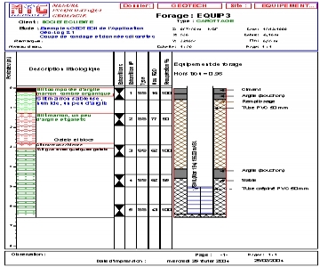
GEO-LOG 3 is a geotechnical data processing software with custom layout of borehole logs. It runs under Windows (XP, Vist, 7) with a standard hardware configuration, by leveraging a Microsoft ® ACCESS 200 database file. The main functions of...
Dips is designed for the interactive analysis of orientation based geological data. The program is capable of many applications and is designed for both the novice user and for the accomplished user of stereographic projection who wishes to utilize...
BoreDM serves geotechnical and environmental firms around the world, including governments, local firms, and multinational corporations. Export logs, cross sections, and lab data to industry-standard formats BoreDM is ready for any pr...
LOGitEASY's web-based soil logging and boring log software (LOGitEASY eForm) is usable both in the field and in the office for transferring field notes. Once the data is entered into the software, logs can be produced in a variety of templates, incl...
CPeT-IT is an easy to use yet detailed software package for the interpretation of Cone Penetration Test (CPTu) data. CPeT-IT is the result of a collaborative effort with Gregg Drilling Inc., a leading company in geotechnical site investigation and co...
HoleBASE SI is a state of the art geotechnical knowledge management system that will help you stay in control of your geotechnical project data and archive. HoleBASE SI’s unique features allow you to manage your data throughout the lifetime of a pro...
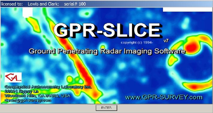
GPR-SLICE V7.0 (1994-2017) is a comprehensive ground penetrating radar imaging software designed for creation of 2D/3D subsurface images for use in a variety of geotechnical, engineering and archaeological applications. GPR-SLICE began developmen...
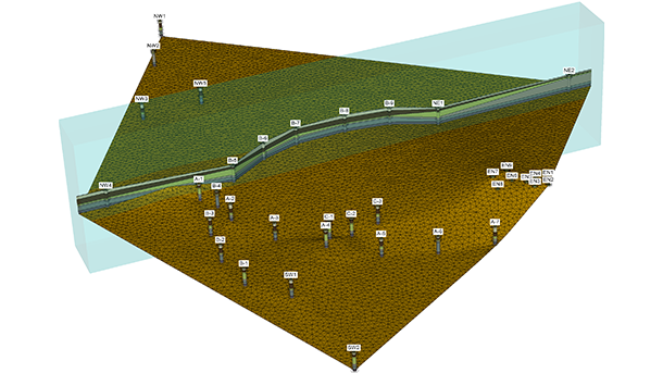
Capabilities Create and visualize geotechnical reports Create fence diagrams Create geotechnical borehole logs Create geotechnical well logs Create specialized geotechnical reports Interoperate with engineering applications Manage s...