A managed code .NET GIS SDK for developing professional web GIS applications for hosting on Windows, Linux, and macOS servers (including Docker). The SDK is designed and compiled natively for ASP.NET Core and Web Forms, with support for MVC and Razo...
A professional grade GIS software development kit (SDK) used by customers in a wide range of industries to develop custom GIS applications or add geospatial functionality to existing products. SDK editions are compiled natively for the Delphi/C++Bui...
Carlson Takeoff is a cut/fill volumes and data prep (for layout or machine control) program that can estimate jobs using paper plan digitizing, PDFs, or electronic CAD files Key features include: Calculate site cut & fill and topsoilDifferen...
RockWorks is the standard in the petroleum, environmental, geotechnical and mining industries for surface and subsurface data visualization, with popular tools such as maps, logs, cross sections, fence diagrams, solid models and volume calculations.R...
Terrain Tools® is a software toolkit for 3D mapping, terrain modelling and land development. Terrain Tools® includes a variety of 3D mapping functions, as well as engineering design functions.Includes functions for: surveying, coordinate geometry, im...
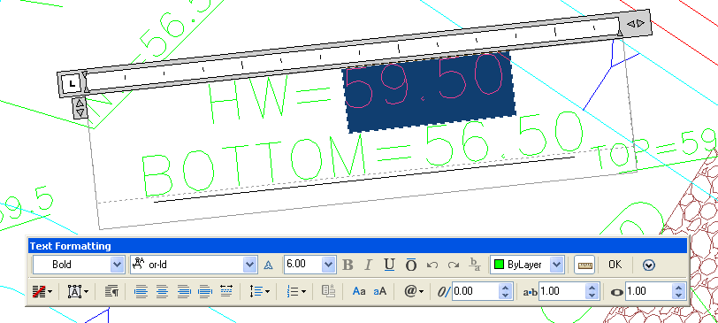
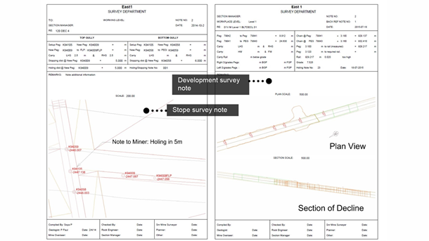
Mine Surveying SoftwareDeliver more up-to-date survey data with MineCycle™ Survey mine survey software. Get survey results faster by slashing the time required to process measurements. Support faster decisions across the enterprise with flexible and...
Versatile solution for change detectionMaptek Sentry is a flexible and cost effective solution for detecting surface change. The system combines I-Site laser scan data with sophisticated software to track and analyse movement over time.The Sentry sys...
Vulcan Surveyor allows collected survey data to be imported into Vulcan for efficient review, manipulation and update. Direct communication with survey technology reduces errors that may occur during file transfers.Surveyor Modules-Download/upload to...
eGeoCompass is an application for Android mobile devices with the following features:•Android operating system, version 1.5 or higher•Processor: 528MHz optimal•Sensors: GPS antenna, accelerometer, compass•Display: minimum QVGA (240×320 pixels) – opti...
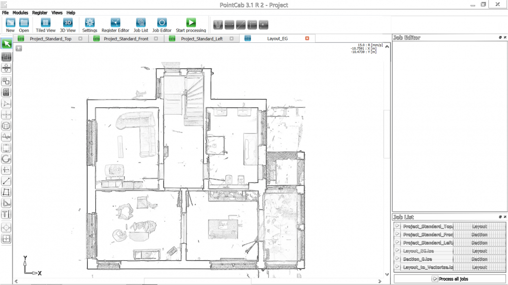
A software for all point clouds.No matter if you need a 2D evaluation, 3D analysis or a neat project documentation – PointCab provides you an intuitive point cloud analysis without the need of training.Focus on your planning activities and not on ana...
The GGU-GEO-GRAPH program allows graphical representation of any kind of measured parameter determined for data points of known x/y coordinates.
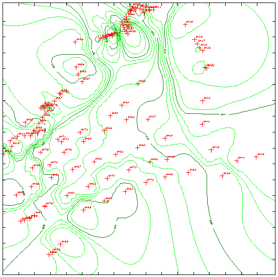
ISOMAP is the module that is used to calculate and render surfaces through contour lines or coloured and shaded areas with a high degree of precision. The program allows the representation of the surface both in topographic map and perspective view f...
Productive workflow and effective results from 3D laser scan data.Powerful, Flexible, FastMaptek I-Site Studio Software is an intuitive point cloud processing package. I-Site Studio is designed for mining, civil, geological and other surveying applic...
I-Site Studio - Geotechnical ModuleThe I-Site Geotechnical module provides geologists and geotechnical engineers with powerful tools for analysing structures and undertaking kinematic analysis. Working directly on laser scan data ensures accurate and...
EUPALINOS is a feature-rich surveying software which covers all tasks and operations necessary to successfully run a tunneling project.The straightforward user-interface with simple database-management requires only a short period of training while m...